
Listen to nature’s voice
Welcome to Wicklow
Mountains National Park
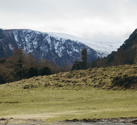
Wicklow Mountains National Park stretches across almost 23,000 hectares south of Dublin. The largest of Ireland’s National Parks and the only one in the east, Wicklow features wide-open vistas, winding mountain roads and fast-flowing streams that descend into the deep lakes of the wooded valleys, including St Kevin’s monastic settlement at Glendalough.
Discover how you can help us conserve the park’s biodiversity and landscape, or plan your visit to explore the uplands on a hike or scenic drive. A true flavour of Ireland’s ancient wilderness awaits you in the park.
Boundary Map of
Wicklow Mountains National Park
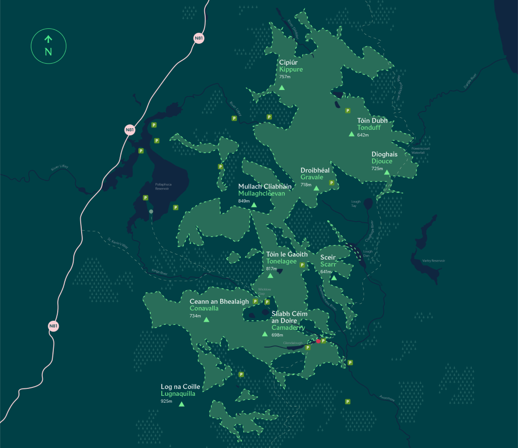
Area
S.P.A:
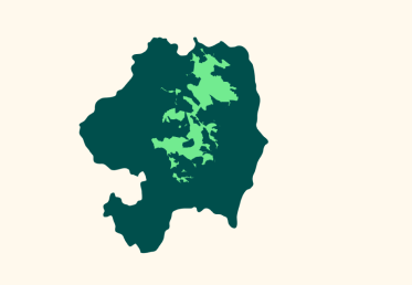
Location in Co.Wicklow
Legend
-
 Parking
 -
 Lake
Lake -
 River
River -
 N81
N81
-
 Mountain Peak
 -
 Coillte Land
 -
 Visitor Centre
 -
 Park Boundary
The detail on this map is generalised: it is not suitable for hill-walking. The map does not show legal title to property. Cartography ©2009 – ESRI Ireland Ltd and the National Parks & Wildlife Service, Department of the Environment, Heritage & Local Government. Based on Ordnance Survey Ireland data. Licence No. EN 0059208. © Ordnance Survey Ireland / Government of Ireland.
News & Notices
Easter Treasure Hunt – All About Hares
Poulanass Closed
Trail Closures after Storm Darragh
Picks of the Park
Spinc Trails
walking & hiking
Enjoy spectacular views of the Upper Lake on the Spinc boardwalk. A good level of fitness and hiking boots required on hill walks.
Upper Lake View
Things to do
Possibly the most photographed view in Wicklow. Always spectacular no matter the weather or time of day.
Military Road
Things to do
Take a drive across the historic Military Road and Sally Gap. Enjoy wide rolling mountain scenery.
Walking & Hiking
Wicklow Mountains National Park is a wonderful place for hill-walking and hiking. Explore our nine waymarked trails and remember the safety basics: check the weather before you set off and bring a map, plus any essentials you’ll need. Help us protect wildlife by always keeping dogs on a lead.
Miners’ Road Walk
Poulanass & St Kevin’s Cell
Green Road Walk
Derrybawn Woodland Trail

Thank you for helping us protect the habitats and wildlife of the Wicklow Mountains National Park. When you enjoy responsible outdoor recreation here, you help us preserve the Wicklow wilderness and everything that makes it unique.

Plan Ahead
Think about the best time to visit and how you’ll travel here, to minimise your environmental impact. Check the weather and make sure you bring everything you need.
Be Considerate
Be aware of how your activities and behaviour can impact nature, the experience of other visitors and those working here. Be mindful of any noise you make and how you interact with others along the way.

Respect Wildlife
Dogs are very welcome but must stay on the lead. If you can, avoid sensitive times for wildlife nesting and breeding.

Travel and Camp on Durable Ground
The marked trails let you take in all the best parts of the Wicklow Mountains wilderness. Only Wilderness Camping is permitted: review the guidelines here.
Leave What You Find
Do take photographs of the landscape and plants, but please leave even the smallest details untouched, so others can enjoy the Wicklow Mountains wilderness just as you did.
Dispose of Waste Properly
Litter is a huge threat to nature. By bringing your waste home, you help protect the park and its wildlife, and keep the Wicklow Mountains healthy.

Minimise the effect of fire
We can’t allow fires of any kind in our national parks. Fires can cause lasting impacts and devastate plants and animals. Talk to our rangers or Education staff if you need advice, and check our Wilderness Camping guide for details.

Walk Safely
We ask all walkers to please wear hiking boots or other suitable footwear. Walking with more than 50 people? You will need a hiking permit.
Heritage & Culture
The history of the Great Military Road is another fascinating aspect to the National Park. As tourists drive over the mountains, it is interesting to remember the original, strategic origins of the road.
Upcoming Events
Join us for activities including walks accompanied by our National Park guides. For the latest events and other updates, see our Facebook page for more details.
– Information
– Maps
– First Aid
– Lost Property
National Park
Open: Year round
Admission: Free (Charges may apply for parking).
Temporary Closures
For operational or safety reasons, we occasionally need to close a particular area or trail. Please heed any warning notices.
National Park Information Office
Open: 10:00AM – 4:30PM
Closures: May be closed for lunch or for staffing reasons
Education Centre
Open: Open to pre-booked school groups
National Park Headquarters
Open: Monday to Friday during office hours. The Duty Ranger is available Monday to Sunday during office hours.
There are three main car parks: the Visitor Centre Car Park, the Upper Lake Car Park and a free car park in Laragh.
Visitor Centre Car Park
This is suitable for visitors to the Monastic City and its Visitor Centre. There is a charge during busy periods. Access to the Upper Lake area is a 20-minute walk along the Green Road.
Upper Lake Car Park
This is located at the end of the road along the valley. There is a charge to enter. Opening hours vary. Please contact Wicklow County Council for details.
Laragh Car Park
Located beside the Woollen Mills and GAA grounds in Laragh, this free car park is a secure facility with staff on duty. It is open daily between 8 a.m. and 8 p.m.
From Laragh Car Park, hill walkers can access the Green Road to Glendalough and all its walking trails. Walkers can follow the Orange route up towards Derrybawn, the Spinc and Mullacor and the Wicklow Way. St Kevin’s Way and Avonmore Way are also close by.
Other places to park in Glendalough
The Glendalough Hotel has paid parking for patrons only.
There is limited parking beyond Glendalough. Small parking areas can be found on the Wicklow Gap by Glenmacnass waterfall and at a couple of places on the Military Road.
Parking safety
Please avoid parking on the road along the valley to the Upper Lake. It is too narrow and parked cards can restrict access to emergency vehicles.
Please park responsibly when visiting the National Park: avoid blocking entrances to homes and land. An Garda Síochana are issuing parking tickets for illegal and dangerous parking.
The National Park covers 200 square kilometres of wild habitat, much of which is not accessible by public transport, although some private tour companies will take coach tours through the park. The valley of Glendalough is accessible by bus. The privately owned St. Kevin’s bus company operates a service from Dublin city centre to Glendalough (www.glendaloughbus.com). There are also Local Link buses from Wicklow Town to Laragh and from Rathdrum to Laragh.
In Glendalough, public toilets are available at the OPW Visitor Centre beside the Monastic City and at the Upper Lake Car Park. There are no public toilet facilities in the rest of the park, but all neighbouring towns and villages have either public toilets or facilities in public houses and restaurants.
A lost property facility is located at the Information Office in Glendalough. It can be contacted on 0404 45425.
There are many accommodation options available in the area surrounding the park including hotels, bed and breakfasts, hostels, self-catering and camping and caravan sites. Find more information on Wicklow Tourism’s website:
Between Laragh and Glendalough there are two hotels and a restaurant that serve main meals and snacks. In season, stalls for chips and ice-creams are located at the Upper Lake Car Park and beside the Monastic City.
Postcards, maps and a number of books are available to buy in the Information Office at the Upper Lake and the Monastic City Visitor Centre. Crafts, woollens, music and other gifts are available to purchase in Glendalough and Laragh villages .
First Aid facilities including an AED (defribrillator) are available at the Information Office. Other emergency services may also be alerted from here.